What Does Maokong Mean?
The real origin of the name Maokong: a pothole-riddled streambed, a Hokkien phrase for pitted terrain, and a Japanese-era land survey that wrote it down with the wrong, cat-shaped characters.
What Does Maokong Mean?
Maokong, written 貓空, is the name of a hillside tea area above Taipei's Wenshan District, and the characters are a Japanese-era surveyor's phonetic spelling of a Hokkien phrase for pothole-pitted terrain, not a reference to cats. The operator itself states that locals called the pitted streambed liâu-khang (皺坑), and that surveyors recording the place name wrote it with the similar-sounding characters 貓空, which stuck. The cat reading is a later back-formation from the written characters.
That is the short answer, and it comes from an unusually good source: the gondola operator's own Chinese-language pages about the Maokong area, which set out the etymology plainly (there is more on the area in things to do in Maokong). The longer story is one of the best on this whole hillside, because it ties a name to a specific piece of geology, a specific colonial-era administrative act, and a specific stream you can still walk to today.
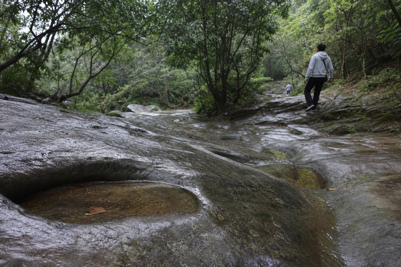
The place being named is a stretch of the Maokong streambed on the slopes below where the gondola's top station now stands. The rock there is igneous, the climate is damp, and the geology is soft, which is exactly the combination that produces stream potholes: stones caught in eddies grind circular hollows into the bed over centuries. The hollows on this stretch are about 20 metres wide and run 100 to 200 metres long, overlapping one another along the channel.
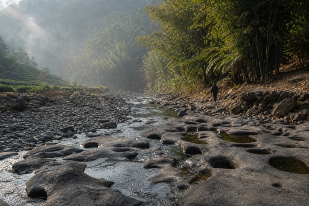
To someone standing on the bank, the pitted bed looked like it had been chewed or wrinkled rather than carved. That visual impression produced the local phrase, and the phrase eventually produced the characters on every map, bus stop and gondola sign you now see. The name is a geological description that survived a change of language, a change of writing system and a change of government.
The cat reading spread because the characters invite it. 貓 means cat and 空 means empty or hollow, so anyone reading the written name without the Hokkien context reasonably concludes "empty cat" or "cat hole". It is an honest mistake, and an enormous number of otherwise careful guides make it. The problem is only that it inverts the direction of the naming: the sound came first, the characters came second, and the cat is a coincidence of spelling rather than the meaning.
If the name has caught your interest, the ride over the terrain it describes is the natural next step, and there are a few sensible ways to book it.
Why Do So Many Guides Say It Means Cat Hole?
Because the written characters genuinely do read that way, and almost nobody checks the spoken origin. 貓空 pairs the character for cat with the character for empty or hollow, so a reader translating the signs literally gets "cat hole", and the reading then gets copied from guide to guide. The operator's own account contradicts it: the name records the pothole terrain in Hokkien, and the cat is a coincidence of the near-homophone characters chosen during the land survey.
There is no shame in the mistake, and it is worth being clear about that. The people who repeat the cat reading are translating honestly from what is in front of them. If a place is written with the characters for cat and hollow, and you do not speak Taiwanese Hokkien, "cat hole" is the reasonable output. The error is structural, not careless: it comes from treating a written form as the original object when the original object was a spoken phrase.
The direction of naming matters. In this case the sound came first. People were calling the pitted streambed liâu-khang, a phrase describing wrinkled or pitted ground, long before anyone had to decide how to write it. The cat characters entered only when the name needed a fixed written form for land registration during the Japanese era, and they were chosen for their sound, not their meaning. Once the written form was locked into cadastral records, it outlived the spoken phrase in official use, and the literal reading of the characters became the one most people meet.
You can spot the cat reading in other guides by a simple test. If a text explains the name as "cat hollow" or "cat hole" and stops there, with no mention of potholes, streambeds or the survey, it is translating the characters rather than reporting the etymology. If it mentions the potholes and the Hokkien phrase, it has done the work. Both readings will keep circulating, but only one of them is what the operator itself publishes.
A related detail that helps the story land: the locals had their own vivid nickname for the potholes themselves. Seen from a distance, the overlapping hollows look like a row of human face masks lined up along the stream, which earned them the name 石面桶, "stone face tubs" or stone face-masks. So the terrain carried two descriptive names, one for the pitted ground that became the place name, and one for the potholes' mask-like appearance. Neither has anything to do with animals.
Should You Book The Ride Before You Go?
The gondola is the reason most international visitors reach this hillside at all, and a one-day pass with unlimited rides on the day of activation is the flexible option if you want to explore the area the name describes.
What Are The Maokong Potholes, Geologically?
The Maokong potholes are hollows ground into an igneous streambed by stones spinning in eddies, a process that takes centuries in soft, wet geology. The operator describes the formation as about 20 metres wide and 100 to 200 metres long, formed in igneous rock in a damp climate with soft geology, and notes that the swirling-stone grinding is what produced the overlapping hollows locals compared to face masks.
Potholes of this kind form wherever a stream carries hard sediment over softer bedrock. A stone lodges in a dip in the channel, the current spins it, and it acts as a drill, cutting a circular hollow that deepens and widens as more sediment joins the grinding. Over hundreds of years, a single dip becomes a tub-shaped hollow several tens of centimetres deep, and a stretch of channel becomes a field of them. The Maokong stretch is unusual in its density and length, which is why it named the whole area.
The rock matters as much as the water. Igneous rock in this part of northern Taiwan is weathered and relatively soft, and the climate is wet enough to keep the stream grinding year-round. The operator's phrasing, damp climate with soft geology, is a compact summary of the two conditions potholes need: enough water to keep sediment moving, and rock weak enough to lose the argument.
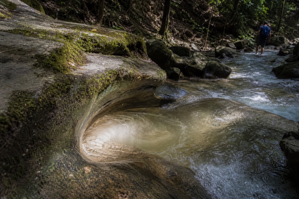
The potholes sit below the tea terraces, near the stream, and the surrounding hillside is what the gondola crosses on its way up. The route runs 4.033 kilometres from Taipei Zoo Station to Maokong Station on roughly the shape of the numeral 7, carried on 47 tower columns standing on 25 pier foundations, crossing the kind of steep, stream-cut terrain that made a cable car more practical than a road in the first place. The city's own project rationale for the gondola noted that Maokong's roads were narrow farm tracks with severely insufficient parking, which is the practical face of the same geology.
That geology is also why the tea grows here. The plantations sit at roughly 300 to 500 metres on hillsides whose conditions matched those of Anxi in Fujian, the original home of Tieguanyin tea. Tea master Chang Nai-miao brought twelve Tieguanyin seedlings from Fujian in 1895 and planted them in the Zhanghu area of Muzha, and the operator states plainly that Muzha is the only place in Taiwan where Tieguanyin is cultivated. The name of the place and the crop of the place both arrived in the same era, one by geology and one by a man with a bag of seedlings.
If you want to see the terrain rather than just read about it, the pass that covers all four passenger stations is the straightforward way up.
How Did A Land Survey Freeze A Spoken Name Into Writing?
During the Japanese era, land across Taiwan was surveyed and registered, and every place name needed a fixed written form. Surveyors recording the Hokkien phrase for the pitted terrain chose the phonetically similar characters 貓空, and once those characters entered the cadastral record they became the official name, outliving the spoken phrase they were meant to transcribe.
This is the mechanism, and it is worth understanding because it is not unique to Maokong. Taiwan's place names were overwhelmingly spoken first. Indigenous, Hokkien and Hakka names described terrain, plants, local events or landmarks, and they circulated by mouth for generations. When the Japanese administration conducted its island-wide land survey in the early twentieth century, officials had to render those sounds in written characters, and the standard method was phonetic approximation: pick characters that sound like the name, without much regard for what the characters mean.
Sometimes the chosen characters were neutral. Sometimes they were poetic. Sometimes, as here, they happened to contain a vivid, misleading image, a cat, that later readers would take literally. The written form then fed back into how people understood the name, because writing has more staying power than speech. Once 貓空 was on the maps and the land registers, the cat was effectively in the name forever, even though it was never in the meaning.
The same pattern explains a fair number of Taiwan's more puzzling place names, where the written characters suggest a story that the spoken original never contained. The general lesson is that a Taiwanese place name written in characters can be a transcription of a sound rather than a statement of meaning, and the way to check is to ask what the name sounded like in Hokkien, Hakka or an indigenous language before it was written down.
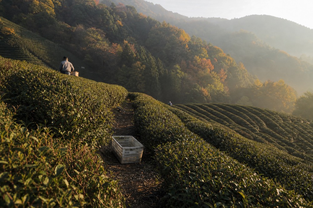
In Maokong's case the outcome is almost charming. The surveyors' spelling gave the area a memorable, slightly mysterious name that travelers puzzle over, and the puzzle sends people back to the streambed, the potholes and the geology that started it all. A name that means "pitted ground" would not have spawned a hundred blog posts. A name that looks like it means "cat hollow" did.
What Does The Name Tell You About The Ride Itself?
The name tells you the hillside is soft, wet, stream-cut country, which is exactly why the gondola exists: the terrain that carved the potholes also made roads up to Maokong narrow and congested, and the city built the cable car to relieve it. Knowing the etymology also enriches the ride, because the 4.033-kilometre route crosses the streams and weathered slopes that produced the pitted bed the area is named after.
Ride up with the name in mind and the landscape starts to read like an explanation. The towers stand on steep, erodable ground, which is why the operator monitors them three-dimensionally: borehole inclinometers watch for landslip under each tower base, ground-level tilt plates take regular readings, and superstructure monitors watch the tower tops. That level of caution is a direct legacy of the hillside's geology, and of the 2008 Typhoon Jangmi landslide near Tower 16 that closed the line for roughly 18 months.
The dampness that keeps the streams grinding is also the dampness that occasionally stops the cabins. Service suspends when gusts reach 16 metres per second and hold for more than three seconds, when gusts exceed 18 metres per second, or when lightning strikes anywhere along the route. If a shutdown strands you at the top, the operator's published procedure is to run free shuttle buses down the mountain, a detail worth knowing before you go and one that almost no guide mentions.
For planning purposes, the fare is now flat rather than by distance: a single journey costs NT$180 per person regardless of how many stations you ride, and a one-day pass costs NT$300. The old NT$70/100/120 station-count scale was abolished on 3 March 2025, so any guide still quoting it is out of date. Concession fares of NT$50 single and NT$100 day pass exist but are restricted to Taiwanese nationals with ID, so overseas visitors pay the general fare.
| The name, layer by layer | What it is | Where it comes from |
|---|---|---|
| The terrain | Overlapping stream potholes, about 20 m wide, 100 to 200 m long, in igneous rock | Centuries of stone-grinding in a damp, soft-geology streambed |
| The spoken name | Liâu-khang (皺坑), Hokkien for wrinkled or pitted ground | Local description of the pothole-riddled bed |
| The written name | 貓空, near-homophone characters meaning cat and hollow | Japanese-era land survey fixing the sound in writing |
| The misleading reading | "Cat hole" or "empty cat" | Literal translation of the characters, ignoring the spoken origin |
| The potholes' nickname | 石面桶, stone face-masks | The overlapping hollows resembling a row of face masks from a distance |
The name, in other words, is a compressed geology lesson that survived a century of administrative change. When you step off at Maokong Station and walk toward the tea terraces, you are standing on the answer to the question tourists ask at the sign, and the operator's own pages are the best place to hear it from. For more on what the area is known for beyond its name, see what Maokong is famous for, and for the crop the name's hillside produces, the guide to Maokong tea plantations and buying tea covers the Tieguanyin story in full. The site, Maokong Gondola, carries the name of the ride that made this hillside reachable, and the hillside carries the name of its own geology.
Whichever way you book, the practical choice is the same one the area's history points to: a day pass over a hillside that rewards being explored slowly, with a name worth explaining to whoever travels with you.
These are the questions travelers actually ask about the name, answered from the operator's own published account rather than the literal reading of the characters. Each answer keeps to the verified etymology: a Hokkien phrase for pitted terrain, a Japanese-era survey spelling, and a pothole streambed you can still visit today.
Common Questions About Maokong's Name
What Does Maokong Mean?
Maokong is the Japanese-era written form of a Hokkien phrase, *liâu-khang*, meaning pitted or wrinkled ground, used for a streambed full of potholes. Surveyors chose the near-homophone characters 貓空, which happen to read as cat and hollow. The name describes geology, not cats, and the operator's own account states this directly.
Does Maokong Mean Cat Hole?
No, although the written characters can be read that way. The cat reading is a back-formation from the characters chosen for their sound during the land survey. The original meaning refers to the pothole-riddled streambed, about 20 metres wide and 100 to 200 metres long, ground into igneous rock by swirling stones.
Why Is The Area Called Maokong If It Is Not About Cats?
Because the name froze a spoken phrase into writing. Locals called the pitted terrain *liâu-khang* in Hokkien; when the Japanese-era survey needed a fixed written form, phonetically similar characters were used, and those characters, not the original phrase, became the official name that spread on maps and signs.
What Are The Maokong Potholes?
They are circular hollows ground into the streambed by stones spinning in eddies, formed over centuries in soft igneous rock in a damp climate. Seen from a distance the overlapping hollows look like a row of human face masks, which gave them the local nickname 石面桶, stone face-masks.
Where Does The Name Story Come From?
From the gondola operator's own Chinese-language pages about the Maokong area, which set out the pothole terrain, the Hokkien phrase and the survey-era spelling. It is a published official account, not a folk reconstruction, which is why it should be preferred over the literal character reading.
Can You Still See The Potholes That Named The Area?
Yes. The pothole stretch sits on the Maokong streambed on the slopes below the top station, and the area's signposted trails, including the Huxue Trail, whose name means pothole, lead through the same stream-cut terrain. The name and the geology it describes are both still there to be walked.